
Missouri Congressional Map Heads to November Vote
State thrown into constitutional "crisis"
Missouri officials are promising to take the state’s congressional map fight to the U.S. Supreme Court after the Missouri Supreme Court blocked the newly drawn districts from being used in November.
The state’s high court ruled unanimously late Thursday that voters must first approve the new map in a statewide referendum. That means Missouri will use its 2022 congressional boundaries in the November general election, even though candidates already ran in August primaries under the new districts. The court’s decision forces voters to choose between candidates they did not approve just last month.
Attorney General Catherine Hanaway quickly announced an appeal.
“Never before in American history has a court overturned a congressional map after a primary and before a general election,” Hanaway said. She said her office would immediately seek relief from the U.S. Supreme Court, calling the situation a “constitutional crisis.”
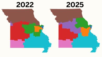
The Missouri FIRST Map, approved by lawmakers last year, would give Republicans a better shot at flipping the Kansas City-area 5th Congressional District represented by Democrat Emanuel Cleaver. Republicans currently hold six of Missouri’s eight congressional seats.
“This is unprecedented,” Gov. Mike Kehoe told Fox and Friends on Friday. “Missourians should have the chance to vote on the candidates in November that they just voted on 30 days ago today.”
Missouri State Senator Rick Brattin, who won his Republican Primary using the Legislature’s redrawn map and was supposed to face Cleaver in November, was incredulous.
“Wow. Missouri citizens got to see judicial activism at work today with the MO Supreme Court decision on the congressional map,” he posted to X. “More than 50,000 voters in the CD5 primary are being dumped into the 3rd, 4th, and 6th Districts, disenfranchised by the stroke of a judge’s pen.”
Supporters of the redrawn map used in August argue the map fixes some of the awkward divisions in the current congressional lines. The old map had taken Jackson County’s more conservative suburban voters out of Cleaver’s district and shoved them into a district stretching all the way to counties just north of St. Louis.
A Jackson County judge earlier this year agreed on several of those points, finding the new map more compact than the 2022 version and noting that it splits fewer counties and municipalities.
The difference is measurable. The 2025 map divides five counties seven times, compared with nine counties split 10 times under the old map. Camden, Clay, St. Charles and Warren counties are kept whole. The new boundaries also put the Kansas City Northland back into one congressional district.
Those changes have given supporters another argument for the plan: It keeps more communities together instead of carving them among multiple members of Congress.
Opponents collected more than 300,000 signatures seeking a statewide referendum. The organization collecting signatures to oppose the new boundaries was based out-of-state. Secretary of State Denny Hoskins rejected the petition, arguing Missouri’s referendum provision did not apply to congressional redistricting.
The Supreme Court disagreed, ruling the petition could proceed. Unless the US Supreme Court overturns the State Court, Missouri voters will now decide the future of the map in November.
Ken Martin with the Democratic National Committee stated, “This is a big win.”
–Alan Goforth