
The spring weather the greater Kansas City area has been experiencing the last few weeks was bound to come to an end. A winter storm warning has been issued for the area today into Saturday evening as a storm moves in through the Southwest.
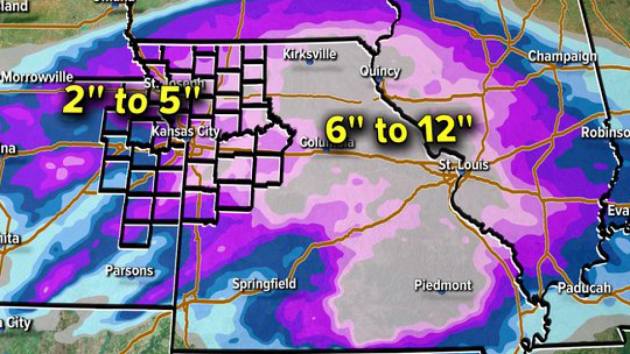
Sleet is already falling in some places across the area but the day promises freezing rain, more sleet and 2-3 inches of snow across the region with some areas receiving anywhere from 2 inches to as much as 5 inches. Areas of Central and Eastern Missouri could see up to 12 inches of snow.
The advisory goes into effect at 6 p.m. Friday and remains in effect until 6 p.m. on Saturday.
Some snow lovers and commuters would have preferred it over the long Christmas weekend.
But it is January so it was to be expected. The Kansas City metro area will see between 2 to 3 inches of accumulating snow, according to the National Weather Service in Pleasant Hill, Mo.
The most likely time for accumulating snow is between midnight and noon Saturday. Heavier snowfall is expected in central and eastern Missouri, where more than 6 inches of snow is possible.
The storm will move into the area tonight, starting out as rain and drizzle that will transition to a wintry mix Friday afternoon with rain intermittently mixing with snow between noon and 5 p.m. Friday evening, the precipitation will change over to all snow, with light to occasionally moderate snow through noon Saturday.
Temperatures will be key in the duration of the snow and rain. If it’s warmer, we could see a lower snowfall range. If it’s colder, we could see higher amounts of snow.